|
In response to the accident at the Fukushima Daiichi Nuclear Power Station caused by the Great East Japan Earthquake, the government issued evacuation orders immediately after the incident to avoid risks to the lives and health of residents, as there was a risk of damage to the reactors and the release and dispersion of radioactive materials. As the severity of the situation escalated, the evacuation zones were gradually expanded. |
|
Through decontamination efforts and the improvement of infrastructure and living conditions, evacuation orders have been gradually lifted. Currently, only areas that are classified as a "Difficult-to-return Zones" remain subject to evacuation orders. The national government and local authorities are implementing various initiatives while considering the well-being of individuals who wish to return to their hometowns. |
("How have the evacuation-designated zones changed over time?" Part 1)When the earthquake occurred, three reactors at the Fukushima Daiichi Nuclear Power Station automatically shut down. However, due to the failure of the cooling systems caused by the tsunami, there was a risk of radioactive materials leaking from the damaged reactors. As a result, the national and prefectural governments issued "evacuation orders" and "indoor evacuation orders" to residents in the nearby areas. Evacuation orders released immediately after the earthquake
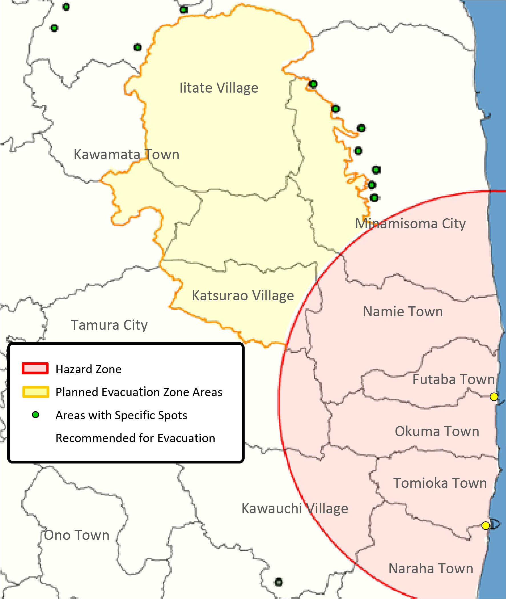
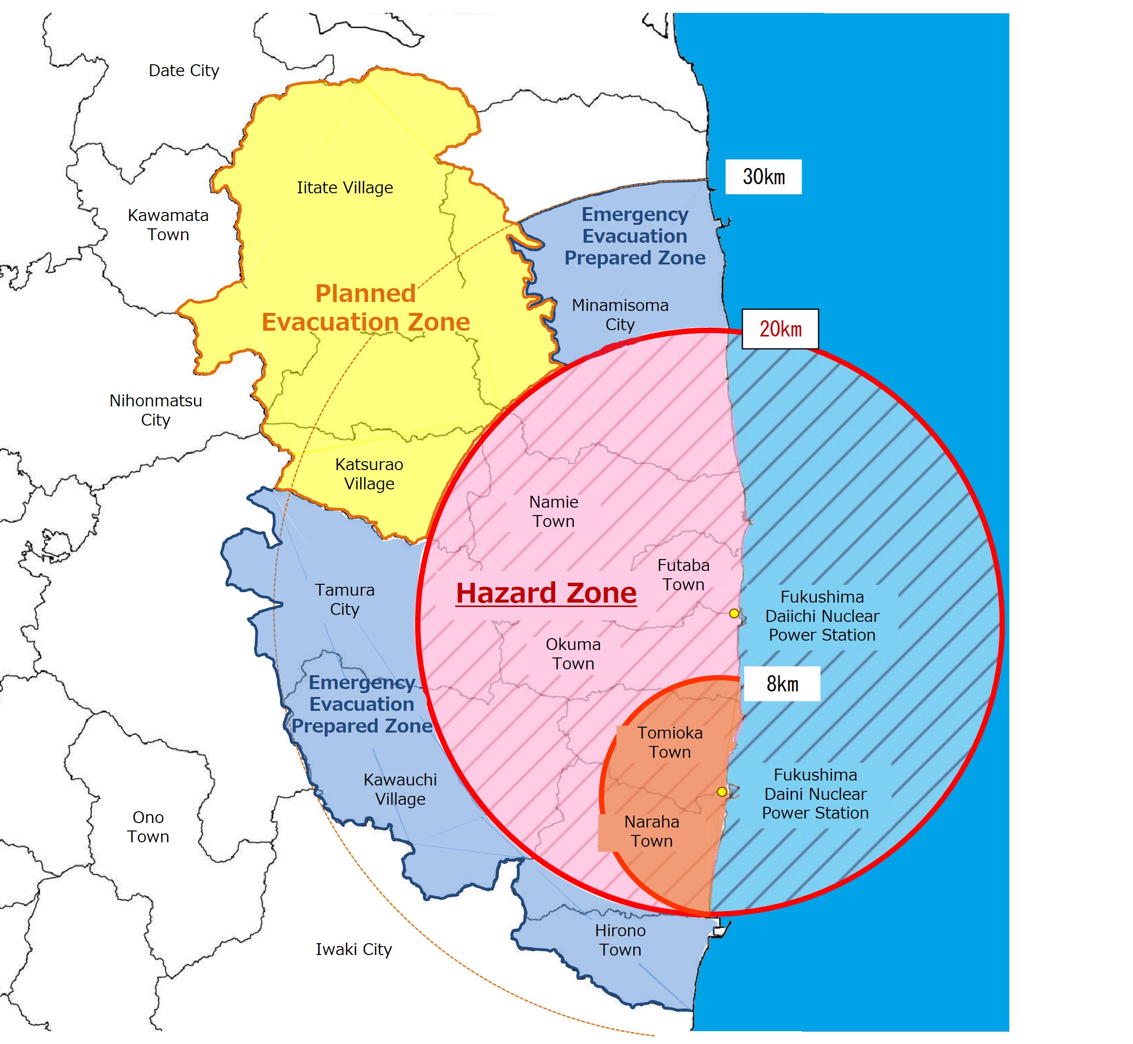
("How have the evacuation-designated zones changed over time?" Part 2)As the amount of leaked radioactive materials gradually became known, three evacuation zones were established while referring to the international standard values (annual dose of 20-100 mSv) for protecting individuals from radiation exposure during emergencies. (22 Apr. 2011) First to be designated was the area outside a 20-kilometers radius from the Fukushima Daiichi Nuclear Power Station, where the accumulative radiation dose for one year was estimated to reach 20mSv, as a "Planned Evacuation Zone" and residents in that area were requested to evacuate. Next, the area within a 20 to 30-kilometers radius from the Fukushima Daiichi Nuclear Power Station was designated as an "Emergency Evacuation Preparation Zone," where residents were advised to either indoor-evacuate or evacuate during emergencies. Finally, the area within a 20-kilometers radius from the Fukushima Daiichi Nuclear Power Station was designated as a "Restricted Zone" where the access was prohibited with a few specific exceptions. As a result, residents who lived in the designated areas of the "Planned Evacuation Zone" and "Restricted Zone" had to evacuate to other locations. Status of evacuation zones (as of 22 Apr. 2011)
Restricted ZonesEntire areas of Tomioka Town, Okuma Town and Futaba Town, a part of Tamura City, Minamisoma City, Naraha Town, Kawauchi Village, Namie Town and Katsurao Village. Planned Evacuation ZonesArea excluding the restricted areas of Namie Town and Katsurao Village, entire area of Iitate Village, a part of Minamisoma City excluding the restricted area, a part of Kawamata Town. Emergency Evacuation Prepared ZonesHirono Town, Naraha Town, Kawauchi Village and a part of Tamura City and Minamisoma City outside of 20 kilometers from Fukushima Daiichi Nuclear Power Station. Lifted on 30 Sep. 2011 ("How have the evacuation-designated zones changed over time?" Part 3)Additionally, other than the "Restricted Zone" and "Planned Evacuation Zone," there were areas known as "hotspots" where it was anticipated that the accumulated radiation dose would exceed 20mSv within one year after the accident depending on wind direction and topography. In response, these areas were designated as "Specific Spots Recommended for Evacuation" and the national government encouraged evacuation. (All designations were lifted on 28 Dec. 2014) Subsequently, as safety was confirmed and prospects for restoring living environments (restoration plans) were set forth based on the reactor status and radiation measurement results, the "Emergency Evacuation Preparation Zone" was lifted. (30 Sep. 2011)" Status of evacuation zones (as of 30 Sep. 2011)
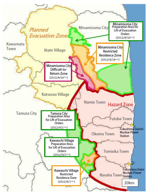
Source: Data compiled by the Ministry of Economy, Trade and Industry and processed by Fukushima Prefecture. ("How have the evacuation-designated zones changed over time?" Part 4)Once it was confirmed that the reactors had achieved a state of cold shutdown, efforts were initiated to facilitate the return of residents and promote the reconstruction and revitalization of the affected regions. As a result, the "Restricted Zone" and "Planned Evacuation Zone" have been reclassified into three zones based on the annual cumulative radiation dose. This took effect on 1 Apr. 2012 Firstly, areas where the annual cumulative radiation dose was confirmed to be consistently below 20mSv became designated as "Preparation Area for Lift of Evacuation Orders ." These zones allowed residents to prepare for their return, enabling flexible access for temporary homecomings (with overnight stays prohibited) and the resumption of hospitals, welfare facilities, certain businesses and agricultural activities. Next, areas where there was a potential for the annual cumulative radiation dose to exceed 20mSv, thus requiring continued evacuation measures, were classified as "Habitation Restricted Areas." Nevertheless, temporary visits by residents and access for road repairs and other purposes were permitted within these zones. Finally, areas where the annual cumulative radiation dose exceeded 50mSv and there was a continued risk of the dose remaining above 20mSv even after five years were designated as "Difficult-to-return Zone." Evacuation is still required to continue for these zones. Status of evacuation zones (as of 1 Apr. 2012)
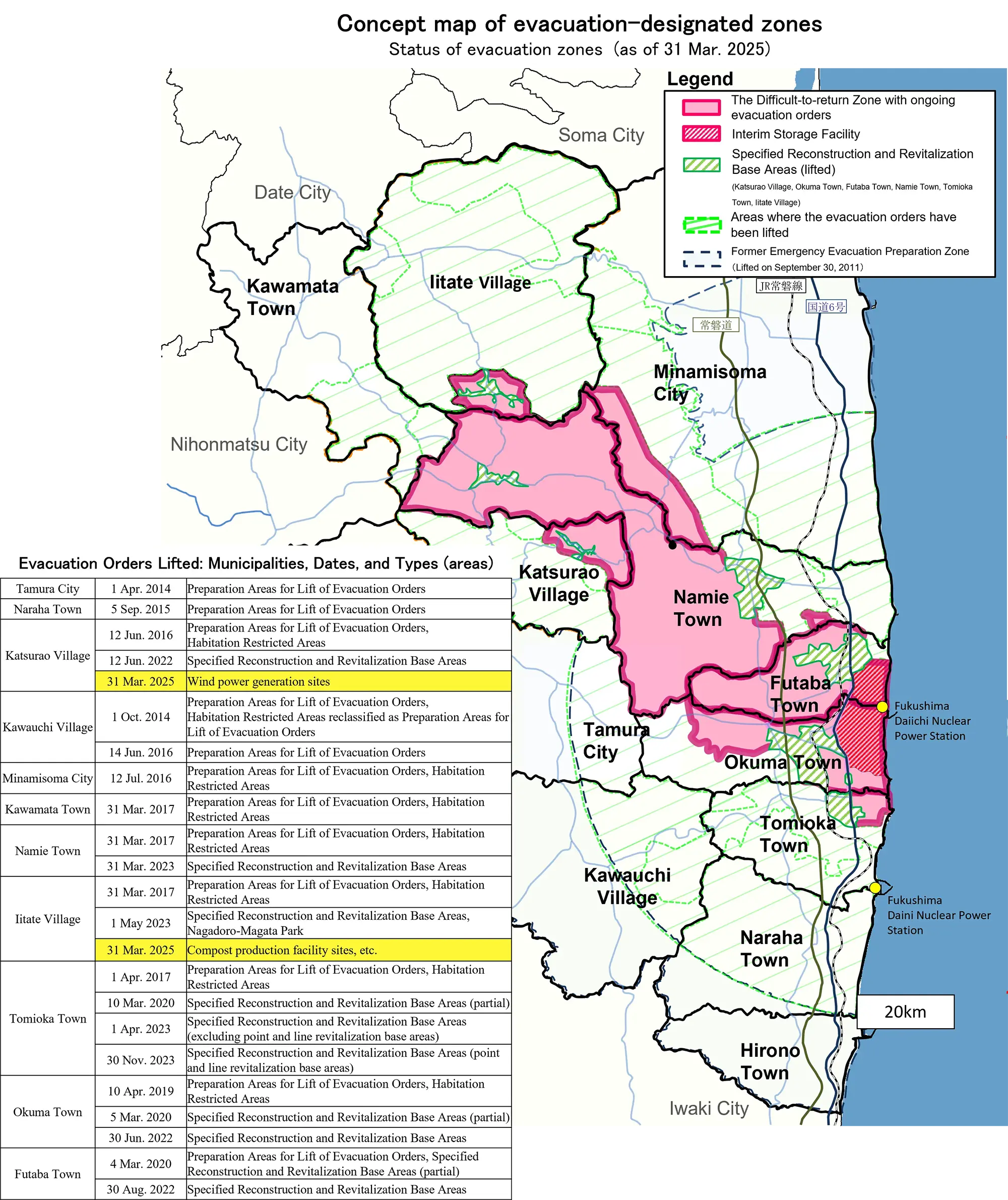
Source: Ministry of Economy, Trade, and Industry ("How have the evacuation-designated zones changed over time?") Part 5As a result of the reassessment of evacuation-designated zones, the former "Restricted Zone" and "Planned Evacuation Zone" have all been reclassified into: 1) "Preparation Area for Lift of Evacuation Orders," 2) "Habitation Restricted Areas," or 3) "Difficult-to-return Zones." Subsequently, evacuation orders have been lifted in various areas including Miyakoji District in Tamura City, Kawauchi Village, Naraha Town, Katsurao Village (excluding certain areas), Minamisoma City (excluding certain areas), Yamakiya District in Kawamata Town, Iitate Village (excluding certain areas), Namie Town (excluding certain areas), Tomioka Town (excluding certain areas), Okuma Town (excluding certain areas) and Futaba Town (excluding certain areas). This has gradually expanded the areas where residents can return. Status of evacuation zones (as of 31 Mar. 2025)
|
|
The "Specified Reconstruction and Revitalization Base Areas" are areas within the Difficult-to-return Zones where residency would have been restricted in the future, but was made possible when evacuation orders were lifted. From June 2022 to November 2023, evacuation orders for all the Specified Reconstruction and Revitalization Base Areas in six municipalities (Tomioka Town, Okuma Town, Futaba Town, Namie Town, Katsurao Village, Iitate Village) were lifted. |
|
The “Specified Living Areas for Returnees” are zones in the Difficult-to-return Zones which are designated separately from the Specified Reconstruction and Revitalization Base Areas, with the aim of allowing residents to return and rebuild their lives after the evacuation orders have been lifted. The towns of Okuma, Futaba, Namie, Tomioka, Minamisoma City, and Katsurao Village have created plans for the establishment of the Specified Living Areas for Returnees and environmental improvement, and received approval from the Prime Minister. Efforts for reconstruction and revitalization are being carried out according to those plans. |


